Thermal risk and biodiversity
Funding: Rutgers Research Council Award (2026–2028)
Role: Principal Investigator
Introduction
Rising temperatures can affect species differently across locations and time periods because warming interacts with other climatic drivers. In this project, I will combine species distribution modeling with explainable artificial intelligence (xAI) to investigate these compound effects for mammals, birds, amphibians and reptiles worldwide. My goal is to assess changes in the contribution of mean annual temperature to modeled climatic suitability and improve spatially explicit estimates of thermal risk for conservation planning.
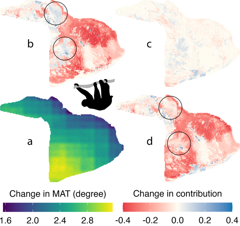
The figure above illustrates projected changes for the pale-throated sloth (Bradypus tridactylus) from 1970–2010 to 2041–2070 under climate scenario SSP370. Panel a shows the change in mean annual temperature. Panels b–d show changes in the contribution of temperature to modeled climatic suitability due to the main, interaction and net effects, respectively.
Structure
Phase 1 will compile species occurrence records and CHELSA climate projections, select ecologically relevant climatic drivers for each species, and develop species distribution models using a downsampled Random Forest approach.
Phase 2 will use SHAP (SHapley Additive exPlanations) to estimate the contribution of mean annual temperature under baseline and future conditions. A mixed scenario, combining future temperature with other climatic drivers held at baseline, will help distinguish temperature-associated changes from the effects of a changing climatic context.
Phase 3 will compare these contributions across locations, species and future periods to estimate effective thermal risk and identify where other climatic drivers amplify, dampen or reverse projected temperature-associated changes in suitability.
Anticipated Outputs
We plan to develop spatial assessments of thermal risk and a reproducible modeling framework for conservation research. The framework can also be adapted to regional conservation planning with more detailed environmental and land-use data.