Mapping Africa
Role: Research Assistant (PI: Dr.Lyndon Estes )
Introduction
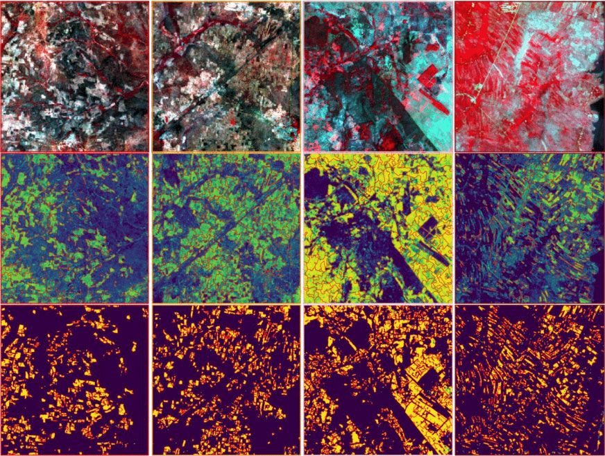
Mapping Africa is a project in which I played a significant role as a Research Assistant in the Agricultural Impacts Research Group (AIRG) at Clark University. It is pioneering an active learning approach to develop a scalable, fast, and cost-effective land cover mapping system that combines human and machine intelligence. This innovative system aims to map the distribution and characteristics of cropland in Africa with unparalleled accuracy.
Co-authored Articles
Estes, L., Ye, S., Song, L., Luo, B., Eastman, J. R., Meng, Z., … & Caylor, K. K (2021). High resolution, annual maps of field boundaries for smallholder-dominated croplands at national scales. Frontiers in Artificial Intelligence, 164. [PDF]
Elmes, A., Estes, L., Avery, R., Caylor, K., …, Song, L. … & Lunga, D. (2019). Accounting for training data error in machine learning applied to Earth observations. Remote sensing, 12(6), 1034. [PDF]
Code Contribution
#1 imager contains scripts in R, Python, and C Language to process PlanetScope images.
#2 labeller contains scripts to run the labelling platform for the active learning.
#3 learner is the machine learning component of the active learning platform.
Hosted by Agricultural Impacts Research Group